How Pokémon Go’s AR Data Became a Centimeter-Scale Navigation System for Delivery Robots
Pokémon Go did not just popularize augmented reality on phones. The game also generated a large, structured image dataset that Niantic Spatial is now using as a visual positioning system for robots, with centimeter-level accuracy in places where GPS often fails. That matters less as a story about gaming and more as a deployment story: crowdsourced AR imagery is being turned into navigation infrastructure.
What changed from game AR to robotics infrastructure
Niantic Spatial’s shift is specific. It trained a model on roughly 30 billion urban images collected through Pokémon Go and Ingress, with each image tied to precise location and orientation data. Because players repeatedly captured landmarks, streets, storefronts, and public spaces from many angles and under different lighting and weather conditions, the result is not just a set of photos but a dense visual reference layer for the physical world.
That corrects a common misreading of Pokémon Go as a lightweight AR gimmick. The game’s visible AR feature was the phone-camera overlay of Pokémon, but the more durable technical asset was the accumulation of geotagged visual observations at scale. Niantic is now repurposing that asset for machine positioning, where the requirement is not entertainment but reliable localization in real streets.
Why visual positioning helps where GPS breaks down
Urban navigation is full of edge cases for satellite positioning. In dense city corridors, signals bounce off buildings, drift near intersections, and lose precision at the exact moments when a robot needs to know whether it is at the right curb cut, storefront, or doorway. A few meters of error can be manageable for a map app and unacceptable for a sidewalk robot.


Niantic Spatial’s system addresses that by matching live camera views against its visual map. If a robot can recognize fixed landmarks from multiple viewpoints, it can estimate its position within a few centimeters rather than relying on GPS alone. The practical gain is not abstract accuracy; it is fewer navigation mistakes at pickup and drop-off points, where small positional errors turn into failed handoffs or route corrections.
| Navigation method | What it uses | Where it works well | Main limit |
|---|---|---|---|
| GPS alone | Satellite signals | Open outdoor areas | Signal drift and reflections in urban canyons |
| Visual positioning | Camera input matched to mapped landmarks | Dense urban areas with rich visual features | Needs strong image coverage and current map data |
| Combined approach | GPS plus visual positioning | Operational robot fleets in cities | Integration complexity across hardware and environments |
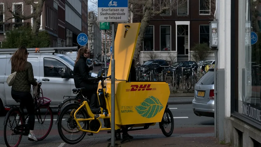
What Coco Robotics is actually using it for
Coco Robotics is one of the early deployment examples. Its delivery robots move at sidewalk speed in cities including Los Angeles and Helsinki, carrying food and groceries through environments that are cluttered, narrow, and constantly changing. For that kind of operation, the hard part is often not general route planning but precise local positioning near the destination.
By combining Niantic Spatial’s visual positioning with GPS, Coco can improve how its robots identify exact spots in GPS-challenged areas. That makes the system useful as an operational layer rather than a replacement technology. The robots still benefit from conventional navigation signals, but visual positioning becomes the correction mechanism when urban conditions make GPS too coarse or unstable.
The game AR was limited, but the data pipeline was not
Pokémon Go’s own AR experience was never a full demonstration of spatial computing realism. It used phone camera and gyroscope data to place Pokémon with approximate perspective and scale, but occlusion and depth handling were limited. A creature could appear anchored to the scene without truly understanding the scene in the way a robot must.
That distinction matters because the consumer-facing AR effect and the underlying spatial data system are different layers. The game experience was constrained by mobile hardware and usability. The image collection process, however, produced a much more valuable byproduct: repeated, labeled views of real places that can support machine perception. In other words, the visible AR was modest, while the infrastructure built around it turned out to be much more consequential.
The next limit is scale, freshness, and governance
Niantic describes the result as a “living map,” meaning the spatial model can be updated as users and robots contribute new imagery. That is important because sidewalks, storefronts, signage, and construction zones change often enough to degrade a static map. A continuously refreshed visual layer is better suited to real deployment than a one-time scan.
The next checkpoint is whether this system can expand beyond urban hotspots where Pokémon Go and Ingress generated dense coverage. The strongest image clusters are likely around landmarks and popular play areas, not every delivery corridor, industrial site, or suburban edge case. The other open question is platform adaptability: different robots have different camera placements, motion profiles, and operating conditions, so centimeter-level performance in one fleet does not automatically transfer to another.
There is also a governance issue that comes with the technical advantage. A visual positioning system built from large volumes of location-tagged imagery raises privacy and data-handling questions that do not disappear because the application is useful. If this becomes infrastructure for robotics, then coverage quality, update rights, retention policies, and acceptable use matter as much as raw accuracy.